
I recently took a long trip through Southern California and tested the features of the Tesla Trip planner in a very remote environment. This particular excursion was not a simple long drive to a single destination estimating the amount of charge needed at each supercharger as I had focused on in my earlier testing of the trip planner with software 7.0. On this road trip I drove to, through, and out of Death Valley National Park – one of the most remote (and beautiful) places on earth with an updated version of 7.1. This post discusses both the current pitfalls with the trip planner software but also some advice for Tesla drivers in remote areas.
The software itself is helpful but the driver still needs to understand how the software works and not get too nervous with strange behavior. The software has improved since my earlier test as the number of false warnings has decreased but many issues still remain. I also discovered a new problem that I had not seen before, but likely was part of the earlier versions.
Always Roughly Plan Your Journey
On any road trip you need to plan to some extent your itinerary. For people who don’t like rigid schedules, I would still recommend estimating distances and travel time for various options on a given day. With gas stations ubiquitous, an ICE vehicle can travel without worrying about filing up, but with an electrical vehicle in remote locations — even with superchargers — some up front planning is recommended.
Tesla recently added some superchargers enabling driving to Death Valley. A few owners had earlier ventured to Death Valley by using a charger at the RV park in the middle of the national park. I was traveling during a busy season (where RV charging can be more challenging), and I also did not want to stay in the park during this visit. I was going to depend upon the three supercharger stations in and around Death Valley: Lone Pine, Inyokern and Beatty. Also in and out of Death Valley National Park only has a few places where you might be able to charge in a true emergency such as in Panamint Springs. But there are many long sections such as between Panamint Springs and Searless Valley where there are almost no buildings of any kind.
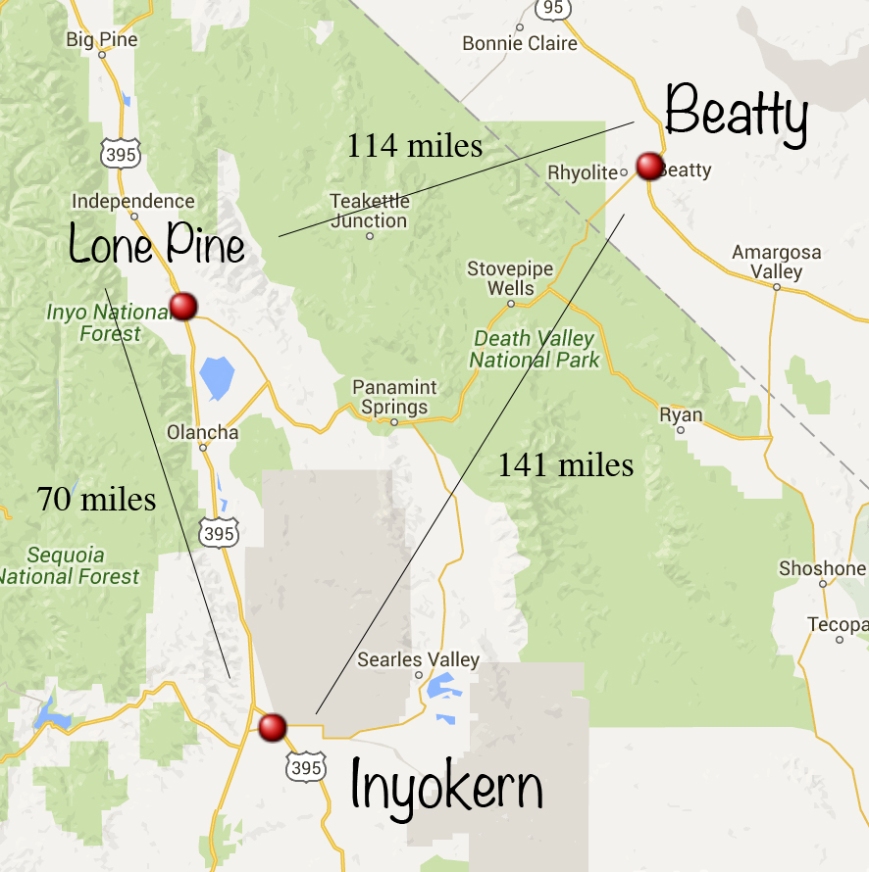
Superchargers Surrounding Death Valley and Distances Between Them
On a quick look at the map, one could think that charging will be no issue. The maximum distance is 141 miles going through Searles Valley and Trona between the Beatty and Inyokern chargers. Unfortunately most mapping software wants you to drive through Olancha. The road through Searles Valley is more interesting, but currently there is a few miles of unpaved gravel road that is under repair. I like using the supercharge.info map more than the Tesla version when planning as the Tesla map is in only in black and white.
The simple mileage numbers do not tell the whole story. The next step is to look at the evtripplanner.com software numbers.
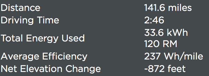
EVtripplanner Estimates From Beatty, NV supercharger to Inyokern, CA supercharger
In some ways although the energy usage is accurate, the overall elevation number is a bit misleading. Starting at Beatty at 3,300 feet, you drop into Death Valley at about 0, but then need to climb back up to Towne Pass near Panamint Springs which is another 5,000 feet in elevation. The supercharger at Inyokern is at 2,434 feet. Although you regenerate a lot of electricity on the downgrade, you can’t recover all of it. Both algorithms in evtripplanner and Tesla’s software do consider the topography during the trip to estimate energy usage.
Watching Energy Use While Driving
You have done a lot of planning and now are actually on your trip. There are several screens you can look at to see if you can make it to your destination safely. But unfortunately Tesla still has not added waypoints, making planning in the car quite difficult. I like to flip between four different indicators when I’m watching my energy consumption as I’m showing in the photo.
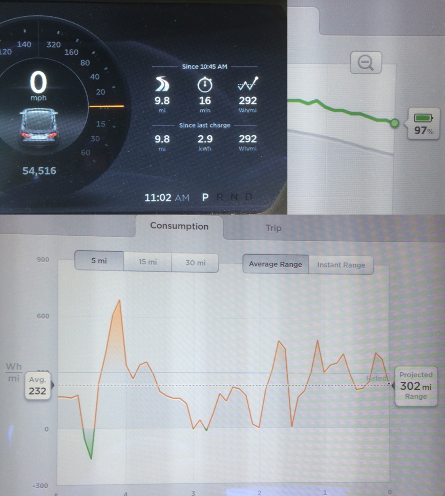
On the dash if you have the energy widget up it will tell you some useful summary information since the last time you charged. Also you can dynamically watch your energy usage while driving. I watch the orange / green power meter. On a gross level, if you are in the green you know you are regenerating energy. If the indicator is above 0, the color is orange. When trying to save energy, the consumption should be between 20 and 40 kW in “normal” conditions.
I would really like this screen to be redesigned. The Miles Per Hour indicator is very large and prominent with the numeric display. Half the tachometer is used up to also indicate the speed of the vehicle with the blue line. I never look at this and the only thing remotely interesting is the listing of how fast the car could technically go. When trying to be cautious of the energy usage, the scale between 0 and 40kW is pretty small. I would really like the entire gauge to be energy usage not half of it to allow me to monitor instantaneous energy usage on the dash itself.
I can also monitor energy usage on two screens on the touchscreen . The consumption tab is the most interesting of the two tabs. Consumption lists average or instantaneous use over 5, 15 or 30 mile sections and at times can be too much information with too many options.
A graph also exists of the overall trip energy consumption as shown in the upper right. This shows you how much energy the trip planner thinks you will use over the course of your trip marked with the grey line. As you are driving and do not match its estimates, the route is shown in green. I don’t use this screen much but it can be useful as it indicates the route’s topography changes. A flat route is a simple line, a mountainous routes will show curves in the graph.
Visiting within the Park
Of course when visiting the park, you simply do not want to drive through it. You want to stop and look around and hike a bit. This requires more energy planning depending upon how far you want to go. A drive from Beatty through Badwater, the lowest point in North America at -282 feet, and to Inyokern would be pushing a 85kW battery.
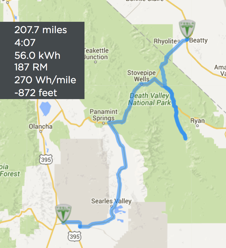
EVtripplanner Estimates Using a Waypoint of Badwater
The estimate is that is 207.7 miles and 56kWh under ideal conditions. My battery has already degraded by 8%, so I actually have a 78kW battery. In the summer, Death Valley is one of the hottest places on earth and filled with European tourists. In the winter it can be extremely cold. On this trip it was a very pleasant winter 80 degrees, but I would not feel comfortable driving all the way down to Badwater and expecting to arrive safely at the Inyokern supercharger. I don’t know the actual weather or wind conditions when I will be driving and I don’t really want to drain my battery down to zero in such a remote location.
Record Wildflowers
My trip happened to coincide with a large wildflower bloom. This last year we have finally gotten some rain in California, and there was actually a bad flood in Death Valley. One result was a very large bloom of wildflowers in the far southeastern part of the park. To get to the best wildflowers clearly required a return to the Beatty supercharger. The photo does not give justice to the sublime beauty of the desert.
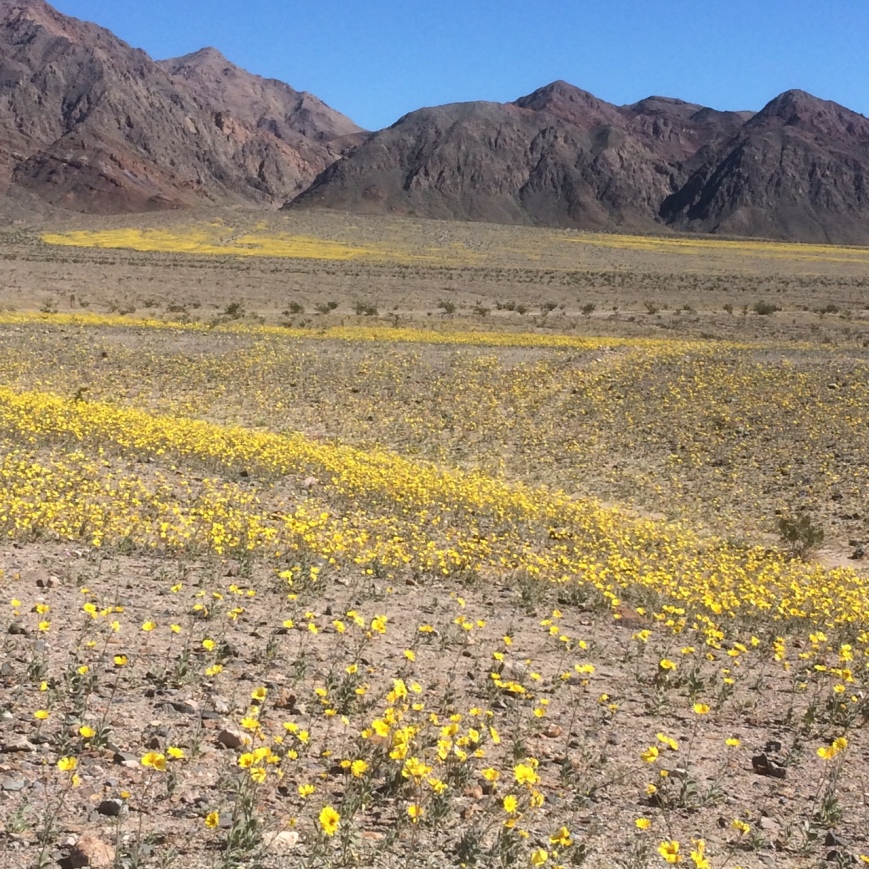
Wildflowers In Death Valley February 2016 Near Ashford Mills
Electrical Options
I did decide to ask various folks at Furnace Creek if I could charge my Tesla. The RV park was full. I inquired at the Furnace Creek Ranch and they clearly stated only guests could charge. The visitor center also had no options. My last place to inquire was at the Timbisha Shoshone Indian Reservation within the park.
I have passed by this small reservation for many years wondering why they never offered any visitor services as they are in the middle of the park. To my great surprise they finally opened up a small eatery. I’m not sure what I am more passionate about saving the environment or social justice. I very happily ate an Indian Taco for lunch made with that delicious fry bread along with some shaved ice. I encouraged them to install an electric charging station as Tesla owners could top off while eating lunch.
Delicious Fry Bread at the Timbisha Shoshone Tribe’s Eatery in Death Valley
When I finished my excursion to the flower fields, the trip planner went a little crazy again. Instead of heading directly back to Beatty, it wanted me to continue on south through the park and into Nevada on a longer course to the Beatty supercharger using a lot more energy and time (shown on the lower right). The day earlier I had the same problem when driving into the park as the trip planner wanted me to go up and around the park (shown on the upper left).
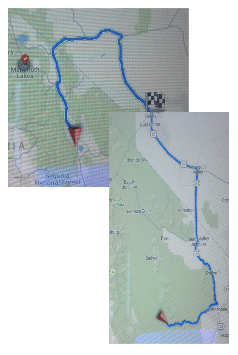
Trip Planner Twice Wanted to Loop Around Death Valley National Park on Longer Routes
After driving in the correct direction to Beatty, the trip planner returned to the correct routing. Over the last ten years or so as GPS devices have become popular, I have a recurrent thought that the current generation of people will begin to loose their sense of direction, or people with a weak sense of direction will learn to depend upon apps like Waze without really understanding where they are headed. In remote areas with a Tesla, a driver needs to truly understand their route.
Lost Connection
When traveling from Bakersfield over to Lone Pine two days earlier, I drove on Highway 178 that was in a deep river valley with no buildings. Many parts of this road had no internet connections, so the software weakness that I reported in my earlier report still exists. The trip planner got completely confused and told me I was going to be out of energy before I arrived at the supercharger.
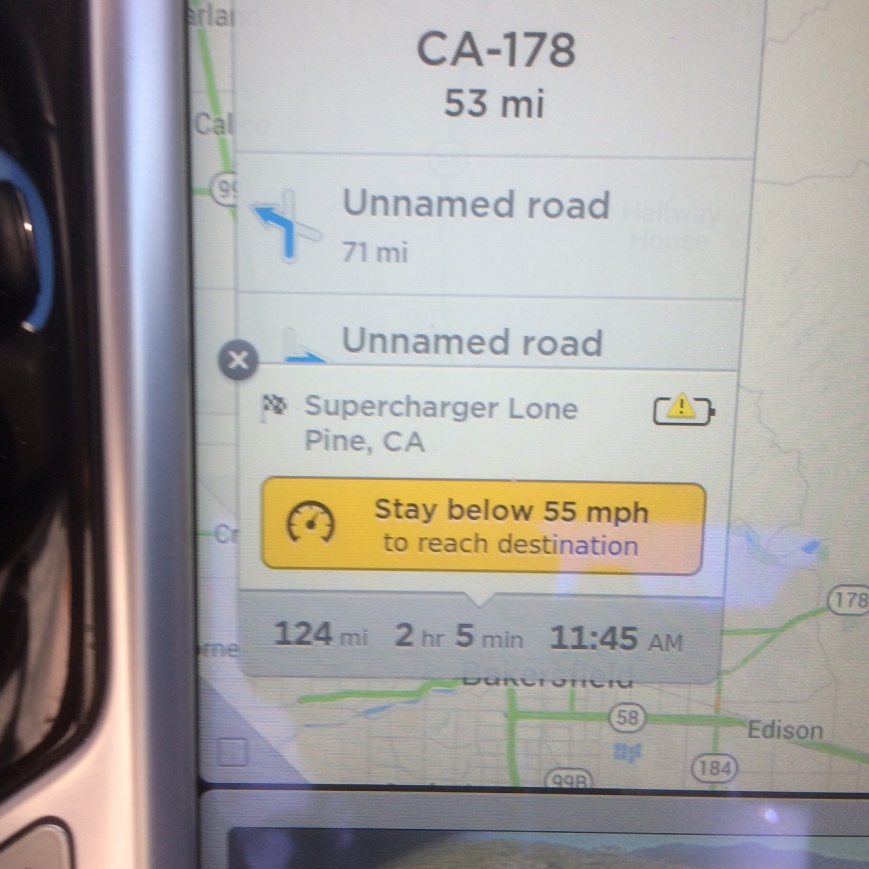
False Warnings From Trip Planner When Cell Connection is Lost
Summary
Until Tesla’s trip planner adds waypoints, EVtripplanner is an essential tool before beginning a journey. With 7.1, the software still issues false warnings and wrong directions. Until EV charging stations are ubiquitous, drivers need to plan their trips ahead of time.


